• Post Falls Dam

  • Photographed by Tom Holman

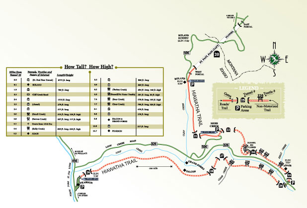
THE HIAWATHA TRAIL: The Route of the Hiawatha is a fun-filled adventure you won’t want to miss.  This groomed biking trail follows what was once the great Milwaukee Railroad, and weaves through the mountain tops of the Bitteroot Divide, which separates Idaho and Montana.  Winding through 10 tunnels and 7 high trestles, with heights up to 230 ft within the Loop Creek canyon, this 15-mile route is an amazing outdoor adventure . The Route of the Hiawatha is best known for the long, dark St. Paul Pass, or Taft Tunnel, which burrows for 1.66 miles under the Idaho/Montana state line. The gentle 1.6% average grade that drops 1,000 feet over the 15-mile length also has shuttle buses available to transport you and your bike back to the top. 
With an incredible history beginning in 1906 of construction, hardships and calamities, unprecedented electrification, and of carrying passengers and freight from the Northwest to the Midwest, generations of railroaders kept the Milwaukee Road running until it finally went bankrupt in 1977. The last train west of Butte, Montana passed through in 1980. After that the line was abandoned.
With government funding and private donations, the rails were removed, and the construction of this spectacular wilderness bicycle and hiking trail was undertaken in 1997. The Idaho portion of the trail first opened for public use on May 29, 1998. The St. Paul Pass, or Taft Tunnel, was completed in May of 2001, and is now open for bike riding.  If you’d like to experience a truly unique mountain adventure, head East on Interstate 90 and get off at Exit 0 for Lookout Pass. Purchase your tickets for the trail, rent bikes and helmets, and also get your bike repaired.  There is a nominal fee and no dogs or pets are allowed on the trail.  Open 7 days a week through September.  Tickets: ridethehiawatha.com

Print Email

Location: East of Coeur d’Alene
Distance: 3.3 Miles
Rating: Moderate

Mineral Ridge Scenic Area and National Recreation Trail

The Mineral Ridge National Recreation Trail is a backcountry hiking area overlooking Coeur d’Alene Lake to the east of Coeur d’Alene. MINERAL RIDGE was the first recreation site developed by the Bureau of Land Management in Idaho. Construction began in 1963 and on April 13, 1982, the trail was designated as a National Recreation Trail.

Mineral Ridge is a “classroom in the forest.” The plant and animal communities are used by local school districts for environmental education. The hike itself is considered moderate and affords enthusiasts sweeping views of the lake and Beauty Bay. Bring your binoculars for eagle watching in January-February. Every year, a population of approximately 150 bald eagles returns to Wolf Lodge Bay to feed on spawning Kokanee salmon. The Mineral Ridge Loop is 3.3 miles long and is open to hikers and mountain bikes. The summit of the Mineral Ridge Trail has an elevation of 2,800 feet, a rise of 660 feet from the parking lot. The main loop trail continues to the west and returns to the parking lot. Most trail-goers hike the loop in roughly two hours. The trail is open from March through November. For more information, visit www.blm.gov.

Print Email

Priest Lake, Idaho
Trail is north of Coolin 7.4 miles on Cavanaugh Bay/ East Lakeshore Road
Mt. Roothaan is 7,326′ and sits just half a mile south of Chimney Rock and is about 200′ higher.
The vantage point offers the best view of Chimney Rock of any 7,000′ footers on the crest.
The Chimney Rock Trailhead 256 is easy access and the trail easy to follow.
12 miles RT to the base of Chimney Rock on the east side. Mt. Roothaan which is just more than 3300′ of gain.

Trail (East Side of Priest Lake)- Hike to the 7,300 foot elevation for incredible panoramic views. The beauty of Priest Lake unfolds nearly a mile below, the awesome grandeur of Chimney Rock seems but an arm’s length away, and the Selkirk Crest surrounds you. It can be yours for a moderate hiking effort and about three to four hours of your time. The Mount Roothaan/ Chimney Rock Trail is a popular route that leads into the backcountry of Priest Lake with spectacular vistas along the way. You can drive your vehicle (high clearance only!) to the trailhead parking area atop Horton Ridge at an elevation of 5,100 feet. From the trailhead, the 2 mile trail leads along Horton Ridge up to a saddle near the crest of Mount Roothaan. The last ½ mile of trail is “mountain goat country” very steep and rocky. The trail continues on to the base of Chimney Rock for those hardy souls who survive the “mountain goat” climb and desire an additional two hours or so of hiking (round trip from Mount Roothaan to Chimney Rock.) Good hiking boots are a must on this portion of the trail as the route passes through an extensive talus field. To reach Mount Roothaan/ Chimney Rock trailhead, travel north from Coolin 7.4 miles on Cavanaugh Bay/ East Lakeshore Road (or 4 miles south from the Indian Creek Campground) to Forest Road #24. This road intersects with East Lakeshore Road immediately north of Hunt Creek Bridge. Turn onto Road #24 and continue for 4 miles until you arrive at a fork in the road. Bear left at the fork onto Forest Road #2. After traveling 1.6 miles, you will arrive at the intersection of Roads #2 and #25. Road #2 continues straight ahead and Road #25 continues off to the right. Proceed on Road #25 for 4.1 miles to the trailhead parking area. The drive from the East Lakeshore Road to the trailhead will take approximately one hour and the hike to Mount Roothaan takes about 1½ hours.

Print Email

Location: Priest Lake
Distance: 5.5 Miles
Rating: More Difficult

Lakeview Mountain Trail #269

This trail begins on the east side of Lakeview Mountain. For the initial 1 ½ mile or so, the trail switchbacks up the steeper east side of the mountain. The first panoramic views of the lake and surrounding mountains are near the 2 mile mark. As the trail descends down the west side of the mountain, several more panoramic viewpoints will attract your attention. This portion of the trail passes through stands of Douglas fir, pine, young cedar and open hill sides. The total length of the trail is 5 1/2 miles and it is rated “More Difficult.” The beginning elevation of the trail is 2,640 feet and climbs to approximately 4,070 feet before descending back down to near lake level.  From the east side the trail is accessed from the Kalispell Reeder trail # 365 about 1 mile south of Elkins Resort.  The western trailhead is located just off Highway 57 between milepost 35 and 36 across from Bismark Meadows. This is a multiple use trail to include foot, mountain bike, motorcycles vehicles and horse traffic.

The trail number refers to the numbering system developed by the Priest Lake Ranger District on the west side of the lake.

Print Email