• Post Falls Dam

  • Photographed by Tom Holman

Morris Creek Trail #132 (East of Sandpoint)
LENGTH: 2.5 miles one way
ENDURANCE LEVEL: Moderate elevation
SKILL LEVEL: Easy to Moderate depending on how long or short.


Morris Creek Trail #132

The trail along Morris Creek provides a lovely walk in the woods, with a moderate elevation gain and occasional glimpses of the peaks towering above.  The trail keeps to the north side of the creek, crossing a couple of seasonal side stream, switch backing occasionally and providing some cool relief from the summer sun.  At about 2.5 miles, the trail crosses the main stem of Morris Creek and then switchbacks up the south side of the valley, through old growth Cedar and Hemlock, with mosses in the under story.  This creek crossing can be difficult to impossible unless the water level is low, such as in July and August.  This is a lovely out and back hike that requires no specific turnaround – it can be as long or short as you would like.

Directions: Take Highway 200 (east from Sandpoint) to Clark Fork.  Turn north at the Chevron Station and follow Lightning Creek Road 419.  At about 6.25 miles, you will cross Morris Creek.  On the north side of Morris Creek is a small turnout. There is a small sign marker with the number #132 on it.

Download a map of Scotchman Peak


Print Email

Star Peak via Historic Big Eddy Trail #999 (East of Sandpoint near the Montana-Idaho border)
LENGTH: 5 miles one way 10 miles total
ENDURANCE LEVEL: Strenuous
SKILL LEVEL: Advanced


Scotchman Peaks Trail #65

Star Peak can be climbed from several trails –  the easiest access is the Big Eddy Trail #999 which starts near the Clark Fork River and climbs into the heavens. Although Star Peak acquired its current name several years ago, long time residents, and some old maps, will know this as “Squaw Peak”.  Climbing a little over 4,000 feet, the elevation gain is greater than on Scotchman Peak, but doing it over 5 miles (one way) the grade is more forgiving, slightly.

#999 has replaced the lower part of #998, an old mining road that switchbacked through the heavily forested lower slopes, with limited views and steep, cobbly stretches. The newer trail, cut by FSPW volunteers, is single track and reaches some great views within a third of a mile from the trail head. #999 intersects #998 beyond where it becomes single track about half way up the mountain. From there, it’s a steady climb through forest sprinkled liberally with huckleberry bushes. Just below the lookout, you will crest a saddle just below the summit and the sight of Billiard Table Mountain will take your breath away.  During the final climb, the views continue to expand into an absolutely stunning panorama.  By the time you are at the old fire lookout, you will know – this is the top of the world!

Highway 200 provides year round access to the trailhead, but beware – snow lingers well into summer on the highest slopes. In the winter this is a difficult but extremely rewarding snowshoe trip – if your thighs are up to the task.  (Only those individuals well experienced in backcountry winter travel should undertake a winter trip on Star Peak.)

Directions:

The trail head is just off of Montana Highway 200 45 miles east of Sandpoint, ID and 45 miles west of Thompson Falls, MT . Near MP 6.5 ± is the intersection of Forest Road #2292, which turns away from the river up the hill. Up the road 100 yards, there is a switchback and the trail head is in that corner. There is room for about four or five cars near the trail head. It’s marked with a brown gilsonite lath with the number 999 on it. Have fun!

Download a map of Scotchman Peak


Print Email

Ross Creek Cedars (East of Sandpoint)
LENGTH: The self-guided .9 mile loop nature trail through the grove takes about an hour to 1-1/2 hours. 
ENDURANCE LEVEL: easy (suitable for all ages)
SKILL LEVEL: beginner
RESTRICTIONS: Open to foot traffic only

Ross Creek Cedars

In summer, the Ross Creek Cedars are a place of cool, quiet refuge.  A shaded canopy of tall cedar boughs provides cool respite from the summer sun, while the large diameter old growth trees offer a measure of solitude even when the parking lot fills up.  Ross Creek softly splashes out its song as it meanders through the grove.  The Cedars tell their own tale to all who will stop, look and listen.  Their story is in the under story of plants, the fire scarred trunks, the rings from downed trees cut away for the trail and the mounds of matter building up around their trunks. Old Marten sets and fresh tracks in the mud offer insights into the lives of many residents.  The earth all around pulses with life.

For profound solitude there is no substitute for a winter walk into these magnificent cedars!  Snow falling softly on a cathedral of Cedars, winter is a magical time.  Here you will find the Scotchmans silent side.  Snow absorbs all sound.  Silence is punctuated only by the occasional woodpecker.  Snow covers the trail and the Devils Club too, freeing you to explore the trees, trunks and tracks to wherever they lead.

For the more ambitious hiker, Ross Creek Trail 142 (4.5 miles in length), is an excellent day hike through a closed canopy of cedars and hemlocks. Be sure to wear hikers that can get wet, as there are a couple of 'bridgeless' creeks to cross on this trail.

In winter: take extra water, food and clothes.  You will need snowshoes or cross-county skis. The winter walk takes on a moderate degree of difficulty.  The access road adds, one way, about 3 to 4 miles with a gradual rise of a few hundred feet and the same descent.

Directions:  To get to the Cedars, take Hwy 200 to Hwy 56 at the “Bull River Junction”.  (About 25 to 30 minutes east of Clark Fork, or about 20 minutes west of Trout Creek).  Turn north on Highway 56, go about 18 miles and watch for the forest service sign for Ross Creek Cedars, turn left.  Follow the signs to the parking lot for the Cedars.  In Winter:  After turning off Hwy 56, the Ross Creek Cedars road it will be plowed, or well traveled.  About 1.5 to 2 miles in there is a wide spot for parking on the main road, while the access road to the Cedars is on the left.  Watch for the signs.  Park there and walk, snowshoe, or ski the access road to the Cedars.


Print Email

Idaho whitewater rafting

Idaho whitewater rafting offers more whitewater river miles than anywhere in the lower 48 states and scenery unlike any other with more than 3,100 miles of whitewater rivers. Trips are offered on a dozen rivers, including the Snake through North Central Idaho - Hells Canyon (the deepest gorge in North America) and the main Salmon, dubbed the “River of No Return” by early explorers. Hells Canyons is breathtaking. It is often said that the rapids are second to the awe-inspiring feeling of being deep in a canyon with steep walls resembling those found in the Grand Canyon. If you are looking for the complete rafting experience, then explore the many Idaho whitewater rafting trips.

What a thrill to be bumping through rapids with names like The Grim Reaper, County Coroner, Bloody Mary, Killer Fang and Ten-Pin Alley, named because the river bounces riders around rocks the way a bowling ball bounces pins.

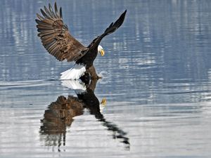
You don’t have to be a thrill seeker to enjoy the sport as many outfitters have trips suitable for children. Idaho whitewater rafting trips vary from one to seventeen day adventures, due to the remoteness of the rivers. Many trips are designed for families looking to expose their children to the wonders of the Great Outdoors. It is not uncommon to see eagles, bighorn sheep and other wildlife. There is also great fishing available. Some feature camping along the water; others include overnight stays at comfortable lodges. Some trips combine boating with hiking, biking and horseback riding; others cater to hunters and fishermen.

One of the most stimulating rafting trips is on the Lochsa (pronounced lock-sah) which rises near the Montana border, runs west along U.S. Highway 12, then joins the Selway to form the Clearwater River east of Lewiston. The Lochsa,(a Shoshone word for “rough water”) one of the state’s wilder rivers with mostly Class III and Class IV rapids (Class V is considered unrunnable), many other rivers offer the fun of boating without as much risk, or sweat.

On the Lochsa, the minimum age is 15, primarily because everybody has to be able to paddle. The paddling, in fact, is somewhat difficult as you are supposed to do it in unison.

Bruneau River Rafting Trips (Class III-IV):
The turquoise waters of the Bruneau River run for 40 miles through a tall canyon of red rock reminiscent of Bryce and Zion National Parks. River trips last four days with beginner – intermediate Class III-IV rapids.

Clearwater River Rafting Trips – Middle Fork (Class I-II):
A relaxing scenic float through the Selway-Bitterroot Wilderness. The Clearwater River offers great wildlife viewing and mild whitewater.

Hells Canyon Rafting Trips – Snake River (Class III):
The Hells Canyon rafting on the Snake River consists of beginner – intermediate Class III-IV rapids. River trip options include rafting 34 miles in three days or 82 miles in six days.

Lochsa River Rafting Trips (Class IV):
Over 40 rapids in 20 miles makes the Lochsa River one of the best options for adventure-seekers anywhere in the United States. This free-flowing, springtime run is one of America’s first Wild and Scenic rivers. On the Lochsa, the minimum age is 15, primarily
because everybody has to be able to paddle. The paddling, in fact, is somewhat difficult as you are supposed to do it in unison.

Moyie River Rafting Trips (Class II-III):
Just a short distance from the charming town of Sandpoint, Idaho, the Moyie River is a delightful and fun one-day rafting trip. Bouncy waves are a good introduction to whitewater and the scenery is stellar.

Salmon River Rafting Trips (Class III-IV):
There a several multi-day trips offered on both the Main Salmon River and the Middle Fork of the Salmon River. Flowing through the remote Frank Church Wilderness, the Salmon is known for excellent fishing, wildlife, and hotsprings.

Selway River Rafting Trips – Lower Section (Class I-II):
A free-flowing mellow springtime run, the Lower Selway is a spectacular scenic rafting trip with a few mild rapids. Wildlife viewing, birding, and fishing are excellent on the Lower Selway River.

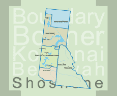
St. Joe River Rafting Trips (Class II-III):
The St. Joe River is located in the panhandle region and runs through one of Idaho’s most lush and spectacular forests. The whitewater on the St. Joe is fun and exciting and is great for beginners or experienced rafters.

Print Email